
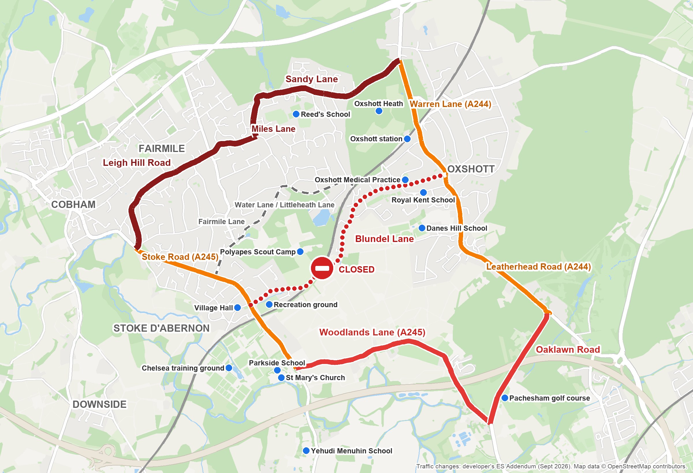
The Paddocks is a plan for 250 homes on Green Belt fields off Blundel Lane, Stoke D’Abernon (application 2025/1097). As part of the plan, the developer wants to close Blundel Lane to through traffic for 8 to 12 weeks and send it onto other roads: by its own figures, about 4,500 vehicles a day, including 482 an hour in the morning peak.
Three stages of disruption
- Temporary traffic lights. First, the bridge goes down to single-file working under temporary lights. The developer expects a delay of 60 to 90 seconds for every vehicle, and doesn’t say how long this stage lasts.
- Full closure for 8 to 12 weeks. The developer’s report describes a “full temporary closure of Blundel Lane to all traffic other than construction vehicles”. Drivers are diverted, adding 5 to 6 minutes to every journey, a delay the report itself rates as “significant”.
- Permanent traffic lights. Once the works are finished, the bridge becomes a 150-metre single-lane section permanently controlled by lights. The developer’s own figures put the wait at around 50 seconds per vehicle, rising to 75 to 80 seconds whenever a cyclist is on the bridge, with queues of 70 to 100 metres at peak times. On top of today’s traffic, it would carry the cars from 250 new homes.
Is your road on the list?
These are the roads the developer’s own report says the closure affects, with its own figures for the change in daily traffic:
| Road | Extra traffic | Impact |
|---|---|---|
| Sandy Lane | +144%, more than doubling | A significant increase in traffic noise, day and night; an “offer of a noise insulation scheme” to homes “should be considered” |
| Leigh Hill Road | +118%, more than doubling | A significant increase in traffic noise, day and night; an “offer of a noise insulation scheme” to homes “should be considered” |
| Miles Lane | Part of the same diversion | No traffic figures given |
| Oaklawn Road | +31% | Nearly a third more traffic |
| Woodlands Lane (A245) | +31% | Every diverted lorry |
| Stoke Road (A245) | +11% to +13% | Both diversions start here |
| Leatherhead Road / Oxshott Road (A244) | +13% | The southern diversion, through Oxshott High Street |
| Warren Lane (A244) | +12% | The northern diversion, on the road to Oxshott station |
| Blundel Lane | Closed | Temporary lights, then up to 12 weeks closed, then permanent lights |
Fairmile Lane, Water Lane and Littleheath Lane aren’t on the developer’s list. Anyone who drives locally knows these narrow lanes are the obvious short cut. The developer hasn’t assessed any traffic on them, but we believe they will be affected.
Email tplan@elmbridge.gov.uk quoting 2025/1097, in your own words. How to comment.
Schools and other places along the diversion routes
If you use Blundel Lane to get to or from any of these places, you will be affected:
Schools: Reed’s School, Danes Hill School, Parkside School, Yehudi Menuhin School, Royal Kent School
Health, shops and travel: Oxshott Medical Practice, Oxshott High Street, Oxshott station
Church and community: St Mary’s Church, Stoke D’Abernon Village Hall
Sport and open spaces: Stoke D’Abernon recreation ground and cricket club, Chelsea’s training ground, Pachesham Park golf course, Oxshott Heath, Till Common, Polyapes Scout Camp
Why this is happening
Part of the planning application is a new footpath over the railway bridge, so people living on the site could walk to Oxshott. This is despite the site being about two kilometres from the nearest primary school and GP surgery, and the developer’s own figures forecasting 122 car trips in the morning peak against 7 by bus or train. The developer even says Oxshott is beyond walking distance for most people. A footpath doesn’t change where the school, surgery and shops are. This is not a sustainable location, and weeks of closures won’t make it one.
Figures from the developer’s own reports on the planning portal.
What you can do
1. Comment by Saturday 31 October
It takes five minutes. Email tplan@elmbridge.gov.uk quoting 2025/1097 and saying you object, or comment on the Council’s website.
Use your own words and your own road: identical comments are grouped together and counted as one. For example:
I object to application 2025/1097. The site is about two kilometres from the nearest primary school and GP surgery, and the developer’s own figures forecast 122 car trips in the morning peak against 7 by bus or train. A footpath over the bridge doesn’t change that: this is not a sustainable location for 250 homes. I live on [Sandy Lane]. To build that footpath, the developer would close Blundel Lane for up to 12 weeks and more than double the traffic past my home, on top of the [school run to Reed’s School]. Please refuse this application.
2. Tell your neighbours, and anyone else who uses Blundel Lane
Most people on these roads haven’t heard about this yet. Please share this page:
- on your road’s WhatsApp group
- in school parent groups and class chats
- with your clubs, church or community groups
- by forwarding it to friends, family and neighbours, or forwarding our email if that’s how you got it
3. Sign up for updates
Sign up for email updates below. You can read more on our Stop The Paddocks campaign page.